
Studies, Plans and Policies
Follow the links below for Town of Nolensville studies, adopted plans, memorandums and polices.
Comprehensive Plan
Comprehensive Plan
Comprehensive Plan Update to language defining Village
Comprehensive Plan Map
Major Thoroughfare Plan (MTP)
The MTP is the Town of Nolensville's general plan for major street system improvements, and its primary objective is to ensure adequate right-of-way and appropriate locations and alignments for the orderly development of the thoroughfare system. Importantly, to provide options for people of all ages and abilities, the MTP coordinates walkways and bikeways into the major street improvements and also includes a greenway system plan. Implementing the MTP will require ongoing cooperation, advanced planning, and continued community engagement.
Full Document:
Major Thoroughfare Plan - Adopted June 2022
Rocky Fork to McEwen Drive Corridor Study
Rocky Fork Road Corridor Study
Updates:
Ordinance 23-06: Amends the MTP to include the preferred "Regional Projects Alignment Option 1". An updated exhibit can be found here.
Ordinance 23-11: Clarifies the road designation of all roads within the Hailey Industrial Area and Johnson Industrial Area from "Local Road" to "Local Commercial and Industrial Roadway"
Walk Bike Master Plan
Land Use Policy
Land Use Policy
PC Resolution 21-02 Future Land Use Map Update
Addressing Manual
Urban Growth Boundary Expansion Project
The Town of Nolensville, along with Williamson County, Brentwood, Fairview, Franklin, Spring Hill, and Thompson’s Station all worked to update the Williamson County Growth Plan. Nolensville evaluated its proposed Urban Growth Boundary (UGB) expansion options in a June 2022 report by STV. The Nolensville UGB is a defined area beyond the city limits in which the Town of Nolensville could grow into.
Williamson County’s existing Growth Plan, which was developed pursuant to the requirements of Public Chapter 1101 was adopted in April of 2001. The Growth Plan established UGBs around each of the six municipalities, as well as four Planned Growth Areas within the County. These growth boundaries have not been altered since their adoption in 2001. Each municipality is evaluating their own respective UGBs, and all proposed changes will be consolidated and considered for approval through a prescribed ratification process at the County.
Past Meetings:
Community Workshop & Public Engagement meeting - Thursday, June 29, 2023, at 6:30pm in the Nolensville Town Hall Chambers.
Public hearing with the Planning Commission on Tuesday, July 11, 2023, at 6:30pm at the Nolensville Town Hall Chambers.
Public hearing with the Board of Commissioners on Thursday, August 3, 2023, at 6:30pm in the Nolensville Townhall Chambers
Public Hearing #1 – Tuesday, November 7, 2023, at 6:00 PM in the Auditorium of the Williamson County Administrative Complex – 1320 W. Main Street in Franklin
Public Hearing #2 – Wednesday, November 15, 2023, at 6:00 PM in the Auditorium of the Williamson County Administrative Complex – 1320 W. Main Street in Franklin
Coordinating Committee meeting – Tuesday, November 21, 2023, at 9:00 AM at the Enrichment Center
Coordinating Committee meeting – Monday, November 27, 2023, at 9:00 AM at the Enrichment Center (if needed)
Coordinating Committee meeting – Tuesday, November 28, 2023, at 9:00 AM at the Enrichment Center (if needed)
The Town of Nolensville workshop meeting and public hearings above focused on the proposed Nolensville UGB expansion areas that were located within the unincorporated areas of Williamson County. Please note that each municipality within Williamson County conducted similar public hearings regarding their proposed UGB expansion areas, and separate notices were provided by those jurisdictions regarding a time and location for the public hearings.
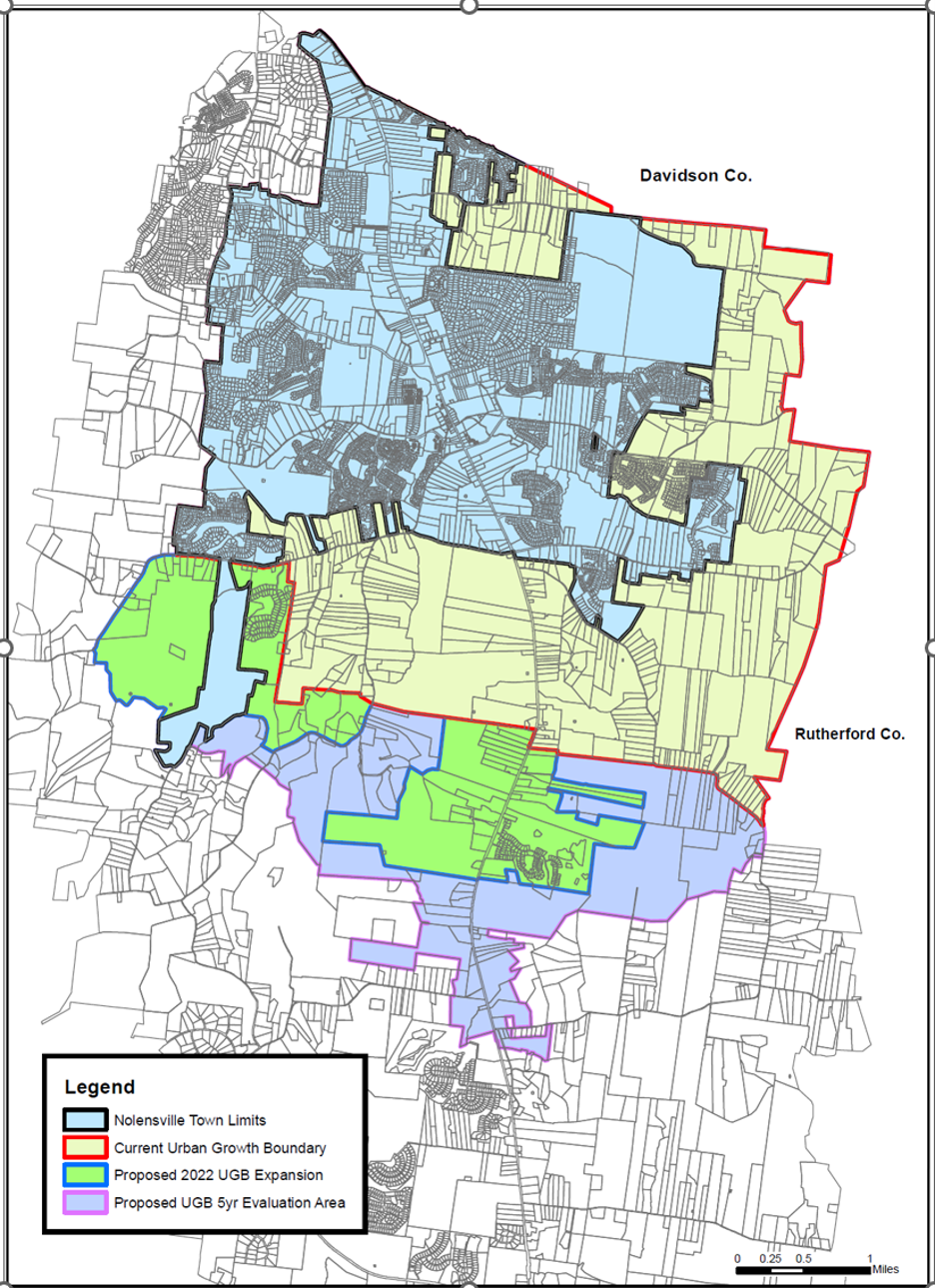
UGB Boundary
Sidewalk plans for Nolensville's Historic District
The Town of Nolensville is continuing to work with Kimley-Horn to move the Nolensville Historic District three-phase sidewalk project forward. The links below are the latest preliminary set provided to the Town. The scope has now been expanded to Sunset Road on the north and Rocky Fork Road on the south. See images below.
Southern extension to Rocky Fork Rd/Clovercroft Rd intersection
Coming Soon
Full Nolensville Historic District Master Plan Rendering
Nolensville's Historic District Rendering Provided by TPUDC
Nolensville Streetscape Prelim Check Set*
Nolensville Grading Concept Markups*
Nolensville Draft Plan*
*Plans to be updated for extended sections of the project
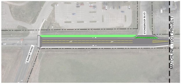
Northern extension to Sunset Road Intersection

Center section in the historic area